
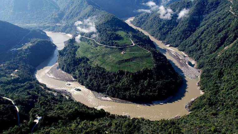
On 26 August 2026 a glacier gave way on Langtang Lirung, on the Nepal–Tibet border, killing hundreds and leaving thousands missing. It showed, in real time, how little warning a Himalayan cryosphere failure gives the communities below it. This assessment uses that disaster as an empirical benchmark against which to measure the risk that China’s Medog dam poses to India — and asks whether India’s principal countermeasure, the proposed Upper Siang Multipurpose Project, is adequate to the threat.
Assessment by Colonel T S Sarkar (Retd) · 31 August 2026
The empirical ground reality: 26 August 2026
A large section of glacier broke away at an altitude of roughly 5,200 metres above the Lhende river in Tibet and fell some 1,200 metres before slamming into the valley below. Early reports mistook the seismic signature for a magnitude 4.4 earthquake. The United States Geological Survey subsequently confirmed that the signal had been generated by the landslide itself, registering as a magnitude 5.2 event. The impact dammed the river; when that debris dam gave way shortly afterwards, it released a hyper-concentrated surge of ice, rock, mud and water.
The surge tore down the Lhende Khola into the Bhote Koshi and then the Trishuli, which rose by as much as nine metres in thirty minutes. It obliterated the Rasuwagadhi border crossing, along with bridges, roads and hydropower infrastructure, and carried bodies of victims as far as 240 kilometres downstream into northern India. As of the disaster authority’s bulletin of 31 August, at least 903 people were confirmed dead in Nepal with 4,247 still missing, alongside 16 confirmed dead and 546 missing across the border in Tibet.
The early-warning failure matters as much as the physics. Automated river gauges, built for the gradual rises of a monsoon, were destroyed by the high-velocity debris wave before they could transmit any data. Confusion between a genuine earthquake and a landslide-generated seismic signal delayed an accurate diagnosis of what was actually unfolding — a preview of exactly the kind of informational blackout that would follow a comparable failure nearer the Indian border.
This was the second such event on the same river system in little more than a year. In July 2025 a supraglacial lake outburst on the Lhende destroyed the Nepal–China friendship bridge at Rasuwagadhi and killed more than a dozen people. The pattern in this corridor is worsening, not isolated.
The upstream infrastructure: the Medog dam on the Yarlung Tsangpo
Construction of the Medog dam — formally the Medog (Motuo) Hydropower Station — officially began on 19 July 2025, when Premier Li Qiang presided over a groundbreaking ceremony in Nyingchi Prefecture, Tibet Autonomous Region. It is worth being precise here: the project was not inaugurated as an operating facility. It broke ground in mid-2025 and is not expected to enter commercial operation until 2033. For the next several years it remains an active, multi-billion-dollar construction site inside one of the most seismically volatile gorges on Earth — which arguably makes the near-term risk profile worse, not better, than a completed structure would present.
Medog dam scale and design
Formally approved in December 2024, the Medog dam is planned as a 60,000 MW cascade of five dam stages along roughly 250 kilometres of the Yarlung Tsangpo, with an anticipated annual output of 60 GW — about triple that of the Three Gorges Dam — at an estimated cost of over ¥1 trillion (roughly US$137 billion). It will be the largest hydropower facility in the world if completed as planned.
Topography and flow
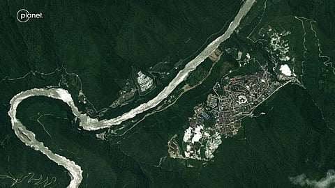
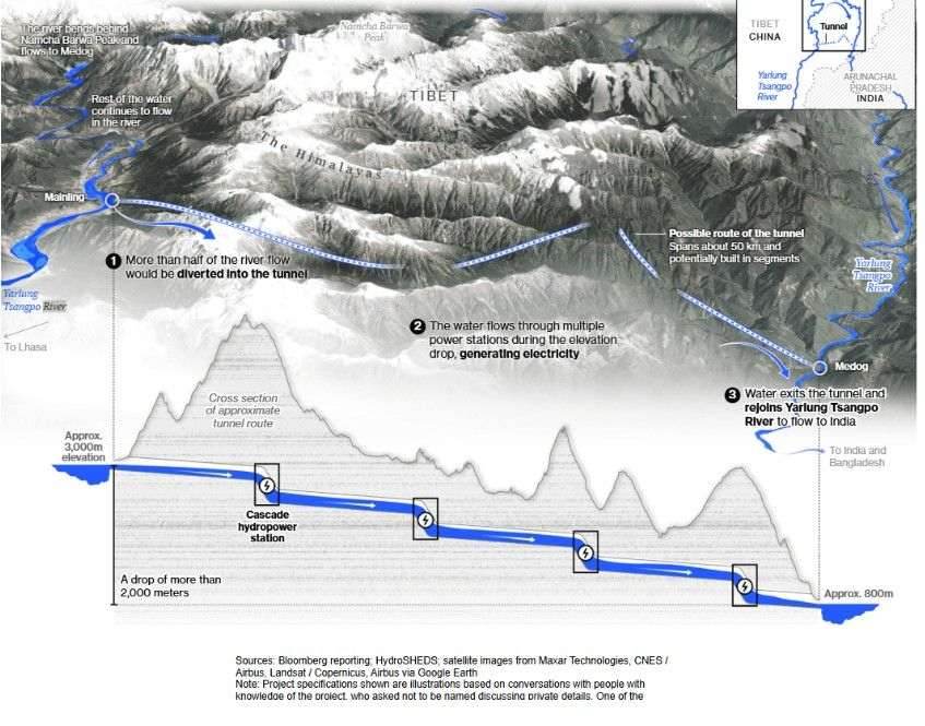
The Yarlung Tsangpo rises near the Angsi Glacier close to Mount Kailash and travels roughly 1,700 kilometres across the Tibetan Plateau before reaching the hairpin “Great Bend” around the Namcha Barwa massif, where the river drops some 2,000 metres within a fifty-kilometre stretch.
The upper river’s own baseline flow supplies only a modest share of the eventual combined Brahmaputra volume; most of that volume is added downstream by monsoon rainfall on the southern Himalayan slopes. That fact tempers fears of the Medog dam being used to permanently starve India of water — even as it does nothing whatever to reduce the risk of a sudden, engineered surge.
Engineering architecture
Rather than a single valley-flooding barrier, the Medog dam cascade combines gravity-dam stages with extensive underground diversion tunnelling. Tunnels roughly twenty kilometres long are being driven through the mountain base at points along the gorge to feed underground turbine halls, alongside more conventional dam structures at other stages of the cascade.
Medog dam proximity to India, and the warning signs already visible
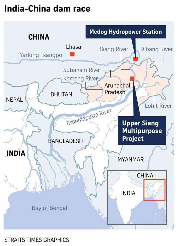
The Medog dam site sits only 30 to 50 kilometres upstream of the Arunachal Pradesh border, squarely inside the Paizhen Fault zone, one of the most tectonically active collision boundaries in the Himalaya.
Before construction was publicly confirmed, downstream observers had already noted prolonged, unnatural discolouration and heavy iron-silt loads in dry, lean-flow winter periods when no rain could explain the change — consistent with large-scale tunnelling and earthworks proceeding in Tibetan territory without prior notice to downstream riparian states.
Medog dam threat matrix: downstream risk to Arunachal Pradesh and Assam
| Threat dimension | Technical mechanics and ground reality | Downstream impact on Arunachal Pradesh and Assam |
|---|---|---|
| High seismic and cryosphere vulnerability | The Medog dam cascade sits inside a hyperactive seismic collision zone prone to major earthquakes and to high-altitude ice-rock collapses of the kind seen at Langtang Lirung on 26 August 2026. | Avalanches or seismic rockfalls can hurl millions of tons of debris directly into intake portals and unfinished construction works with little warning. |
| Subterranean blockages and water hammer | Channelling a heavy silt-bearing Himalayan river into closed concrete tunnels creates real vulnerability to intake choking, during construction and operation alike. | If debris blocks a tunnel while glacial melt continues upstream, hydrodynamic pressure builds behind the blockage, risking a structural burst and a sudden breakout wave. |
| Gradient compression and plain-level inundation | Surges accelerating down steep Tibetan gorges hit a dramatic flattening of gradient at the Indian border — roughly 0.62 m/km at Pasighat and under 0.1 m/km across the Assam plains. | Loss of hydraulic velocity forces water, silt and boulders over the banks, threatening agrarian and residential inundation across districts such as Dhemaji and Dibrugarh. |
| Transboundary data blackout | There is no standing real-time bilateral hydrological, meteorological or engineering data-sharing arrangement between Beijing and New Delhi. | Downstream authorities operate with essentially no predictive warning window — a gap made starkly visible by the automated gauges that were destroyed before transmitting any data in Nepal. |
India’s counter-strategy: the Upper Siang Multipurpose Project
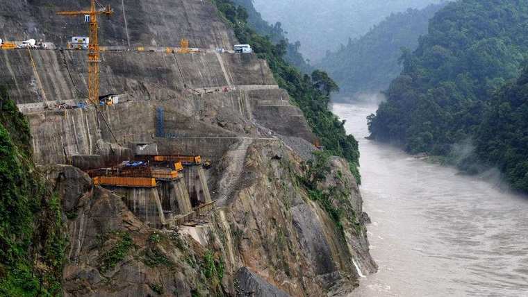
The Upper Siang Multipurpose Project (SUMP), under the National Hydroelectric Power Corporation, is planned as an 11,000 MW storage-type mega-dam near Geku village in Arunachal Pradesh’s Upper Siang district. It would impound a reservoir of roughly nine billion cubic metres behind a dam wall estimated at 280 to 300 metres — designed explicitly as a flood cushion capable of absorbing a sudden artificial release or flash surge from upstream, while also regulating lean-season flows.
This is the detail most often glossed over in coverage of SUMP as India’s answer to Medog: the project remains in the pre-construction, planning stage and has not received final execution approval. It is currently stalled amid sustained grassroots opposition from the Adi indigenous community and groups such as the Siang Indigenous Farmer’s Forum, centred on displacement and submergence concerns. Whatever its strategic merits on paper, SUMP is not yet a physical fact on the ground.
Critical evaluation: is India’s approach adequate?
A large storage reservoir is, in principle, the only physical mechanism capable of absorbing a sudden upstream flow manipulation or surge. But treating SUMP as a standalone answer overstates its near-term adequacy on at least four counts.
- The “dam-on-dam” seismic hazard. A 300-metre mega-dam sited downstream of a 60 GW cascade, inside the same volatile collision zone, concentrates rather than diversifies risk — a major earthquake or an upstream breach could stress both systems simultaneously.
- Construction lead-time vulnerability. Mega-storage projects of this scale typically take a decade or more to build. Unfinished coffer dams and diversion works are themselves exposed to exactly the kind of sudden flash surge the finished project is meant to guard against.
- The speed–distance paradox. With the Medog dam only 30 to 50 kilometres from the border, a high-velocity surge could reach Indian territory in minutes to a few hours — close to no operational response window at all, reservoir or not.
- The politics of getting built at all. Local opposition has stalled SUMP before groundbreaking. A strategic countermeasure that exists only on paper provides no protection; resolving the resettlement and consent questions is now as material to India’s downstream security as the engineering itself.
Recommended way ahead
- Real-time cross-border data integration. Pursue formal, institutionalised bilateral hydrological and meteorological data-sharing with China, alongside multilateral arrangements involving Nepal and Bangladesh, to secure continuous telemetry rather than post-hoc disclosure.
- Decouple early warning from human verification. Deploy autonomous, ruggedised acoustic and seismic sensor arrays directly within the upper gorges, capable of triggering automated cell broadcasts and sirens without waiting for a human analyst to distinguish a landslide signal from an earthquake — precisely the confusion that cost precious minutes in Nepal.
- Decentralised basin resilience. Pair large structural storage with community-level disaster preparedness, pre-mapped high-altitude evacuation routes, and satellite-linked communication meshes that keep functioning when fibre and mobile networks fail.
- Resolve SUMP’s consent and resettlement questions on their own timeline. Treat local opposition as a security variable, not a side issue — a stalled project offers no flood cushion at all, however sound its engineering case.
Conclusion
The August 2026 Langtang Lirung collapse was not a distant warning. It was a demonstration, on the same mountain chain and within the same season, of how quickly a high-altitude ice failure becomes a wall of water in an inhabited valley, and of how completely conventional monitoring fails at the moment it is most needed. The Medog dam places infrastructure of unprecedented scale inside that same class of terrain, thirty to fifty kilometres from Indian territory, with no data-sharing agreement and no warning system designed for the speed at which such an event travels. India’s answer to it currently exists as a planning document opposed by the people who would have to make way for it. The engineering case for storage is sound; the assumption that storage alone constitutes a strategy is not.
Related CENERS-K analysis: The Siliguri Corridor: Securing India’s Northeast, and the centre’s wider regional coverage on the Regions pages.
Sources. Al Jazeera, “Nepal–Tibet floods: What happened, what caused them and who is missing?” and “Satellite images show destruction from Nepal–Tibet floods”, 27 August 2026; Wikipedia, “2026 Nepal floods” (updated through 31 August 2026); EarthSky, “Nepal flash flood nightmare: What caused it?”; The Diplomat, “What’s Driving China’s Mega Medog Hydropower Project?”; Wikipedia, “Medog Hydropower Station”; The International Risk Podcast, “The Dam of All Dams”; Wikipedia, “Upper Siang Hydroelectric Project”; Bangladesh Defence Journal, “The Brahmaputra Design: The Siang Upper Multipurpose Project”; Deccan Herald, reporting on SUMP local opposition, 2026.
Note on figures. The photographs, map and schematic reproduced above are credited to their original publishers in each caption and are used here for analytical illustration.